Eclipse Day Cloud Coverage Model at T-150 Hours
We’re back! Even I have to work sometimes, but -good news!- there still isn’t any real consensus about the forecast to share.
Here we go:
European Centre for Medium-Range Weather Forecasts

Link to the original content: https://weather.us/model-charts/euro/usa/total-cloud-coverage/20240408-1800z.html
Well, compared to yesterday’s forecast, Texas, Arkansas, and Upstate New York’s forecasts were downgraded. Most everything else remains the same.
Global Forecast System
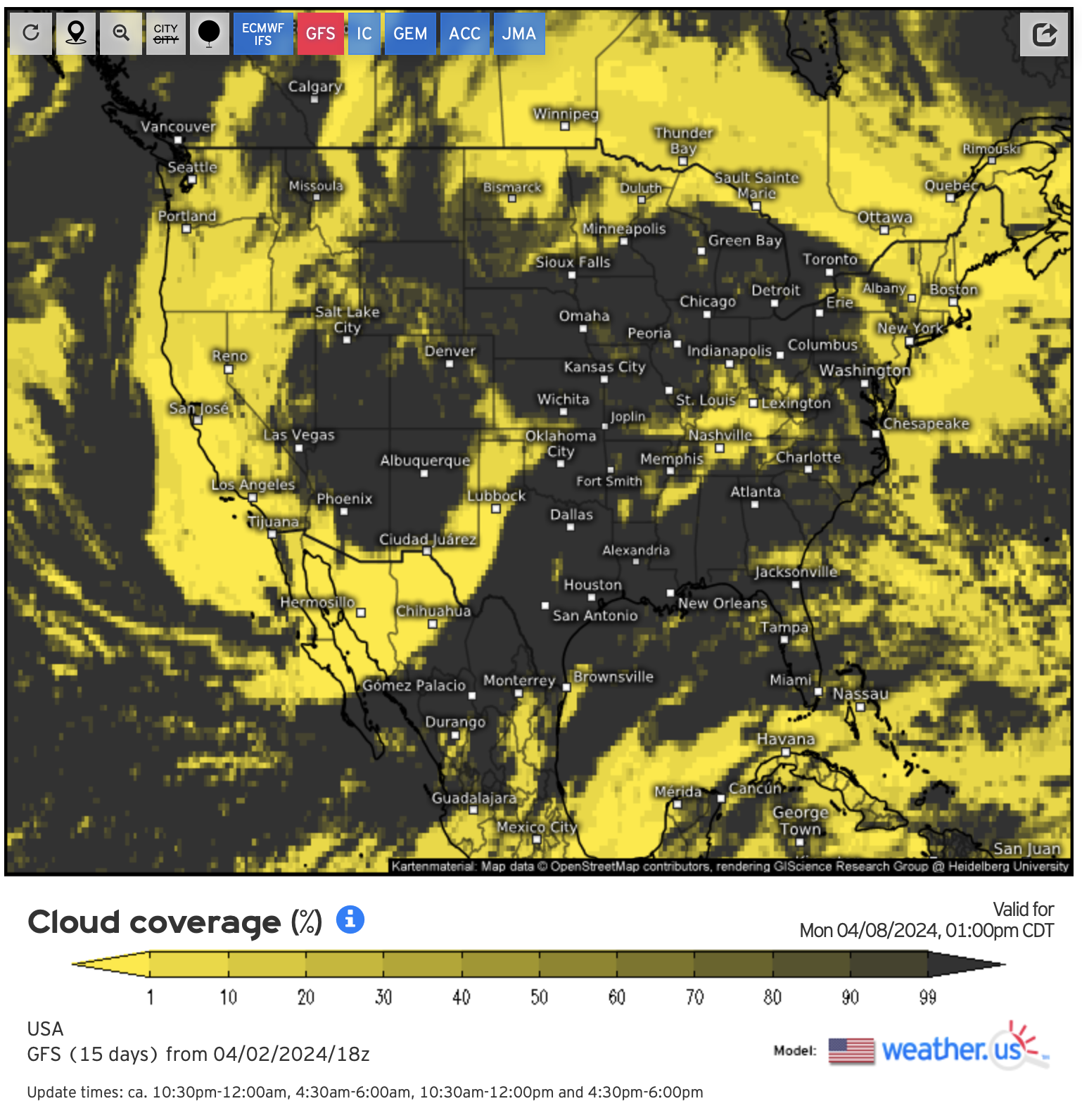
Link to the original content: https://weather.us/model-charts/standard/usa/total-cloud-coverage/20240408-1800z.html
The GFS also remains mostly unchanged, with a small downgrade in parts of Upstate New York while Southern Indiana is marginally improving.
Global Environmental Multi-Scale Model

Link to the original content: https://weather.us/model-charts/can/usa/total-cloud-coverage/20240408-1800z.html
GEM has doubled-down on the concept of a front moving to the east of the MIMAL states during totality, with Ohio and Indiana’s forecasts significantly downgraded.
Australian Community Climate and Earth-System Simulator

Link to the original content: https://weather.us/model-charts/aus/usa/total-cloud-coverage/20240408-1800z.html
ACCESS improved its outlook for parts of Ohio and Indiana, although it still calls for patchy clouds. Texas’ forecast has taken a step backwards, while Mazatlan now looks like a total mess.
Japan Meteorological Agency
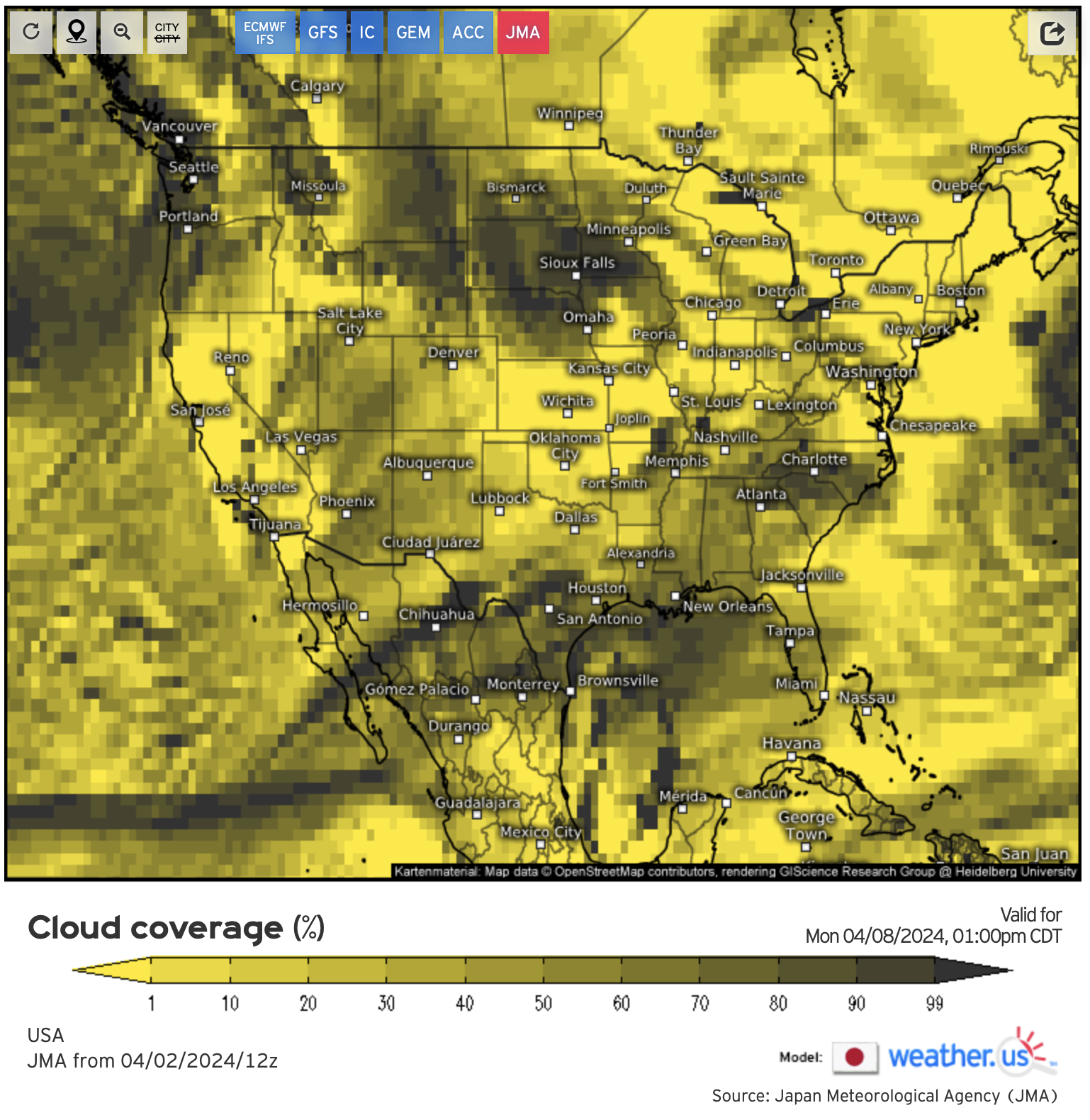
Link to the original content: https://weather.us/model-charts/jpn/usa/total-cloud-coverage/20240408-1800z.html
The JMA is eerily similar run-to-run, with it also pushing the front east of the MIMAL states.
Icosahedral Nonhydrostatic

Link to the original content: https://weather.us/model-charts/german/usa/total-cloud-coverage/20240408-1800z.html
As with other forecasts, ICON has the front moving further east … but also more south than the others. Texas’ outlook as been downgraded slightly while Central Arkansas is a wash.
T-150 Mean Cloud Forecast and Implications

The mean is still a grey mess, with the only major differences overall being an improvement of Southern Illinois’ collective outlook, while Upstate New York’s has taken a small downgrade.
I think the key takeaway from this run is that models are getting more consistent with themselves as time goes on … but not with each other. This suggests there is still a high degree of uncertainty in the models, so I still recommend holding off on making rash travel change decisions.
The “upside”? Even if you wanted to change locations, there aren’t too many options which are seen as cloudless on all six models:

T-150 Clear Cloud Forecast with Path of Totality

A small change, I am going to be posting the cloudless map with the path of totality moving forward..
I’ll be following up intermittently, so stay tuned for more!
—————
Disclaimers: The information from weather.us included herein is done in a manner consistent with its terms and conditions, which you can read here. H.D. Hunt Photography is a noncommercial website and recognizes the copyright for this material is retained by the originator.
You can support H.D. Hunt Photography through a follow on Instagram: