Caracol & Actun Tunichil Muknal
Days Three, Four, & Five - Belize & Guatemala - 2017
Two days exploring the Maya site of Caracol, and the mysterious Actun Tunichil Muknal cave.
Base Map Credit: OpenStreetMap
Base Map Credit: OpenStreetMap
1. Hawkesworth Bridge
Opened in 1949, Hawkesworth Bridge remains Belize’s only suspension bridge.
As you can see, Hawkesworth Bridge is a one-lane bridge, carrying traffic west-to-east on the Western Highway. It connects San Ignacio and its sister city, Santa Elena. A second, wooden bridge across the Macal River connects the two towns downriver. I was unable to get a photograph of it, but -at the time, anyway- this wooden bridge was a newly-opened, temporary version as the “original” wooden bridge, which was swept away in 2016 by Hurricane Earl. Folks mentioned to me that the Hawkesworth Bridge was forced to carry traffic both ways before the temporary bridge was opened, and traffic backed on either side for hours. They also mentioned that when the Macal River’s water level is high, it will also close. So, top tip: when planning a trip to San Ignacio (or, Guatemala from Belize), be sure to double-check the status of the wooden bridge; otherwise, you may arrive significantly later at your destination than anticipated.
2. Beside Marleny’s Store
The village of San Antonio is propped up almost entirely by tourism due to its location next to the expansive Belizean jungle.
En route to Caracol, we stopped at Marleny’s Store in the village of San Antonio, located at the edge of the vast jungle which protected archaeological marvels such as Caracol so well. Nowadays, San Antonio and adjoining towns such as Cristo Rey and Negroman serve as support towns for the large, high-end resorts which surround them. I can’t help but believe Marleny’s Store, a bodega in San Antonio, derives a large portion of its business from passing by tour vans. As the old saying goes, “Location, location, location.”
3. Abandoned Barracks of Douglas Da Silva
Abandoned buildings along the jungle road to Caracol make for an eerie sight.
As you make your way from the Western Highway to Caracol, you will -seemingly out of nowhere- pass what appears to be an entire village of abandoned buildings. I never did get a straight answer as to what these buildings were or why they were left in such a state. Here’s what I was told: the buildings were once associated with the nearby Douglas da Silva Station of the Mountain Pine Ridge Forest Reserve. This station still exists today, and you must stop at it before making your way to Caracol. But the current iteration of the station is a few small buildings, so what necessitated the once dramatic presence? I heard three -yes, three- separate reasons why traveling around San Ignacio - the buildings were military barracks which existed to 1) stop illegal poaching and cross-border smuggling in this remote part of Belize, 2) support joint Belizean-British jungle warfare training exercises, or 3) act as a hedge against Guatemalan invasion of Belize. Whatever the reason, they sure are creepy.
One other tip while we are talking about Douglas da Silva Station: vehicles are prohibited from passing beyond the station unless in a military-style convoy. Why? I don’t know for sure, but probably to 1) regulate the flow of tourism, and 2) stop having to rescue self-driving tourists at all hours of the night. My point is this: the convoy leaves for Caracol in the mid-morning, and -unless you want to be disappointed and not be able to reach this amazing site- I suggest you find out exactly what time you need to be at Douglas da Silva to catch it. Alternatively, join a tour and let someone else worry about the next 90-minutes or so of potholes.
4. Macal River Crossing
The Macal RIver is wild and wonderful - and home to Morelet’s crocodiles.
Strange how in the middle of the jungle, miles from anything resembling a village, there would be a giant concrete bridge across the same river which some ways downriver is crossed by a wooden bridge connecting two cities….
Nonetheless, our convoy stopped here for a quick peak at a crocodile which was splashing around in the river. Always the contrarian, I naturally took a photo in the opposite direction so no one would be in my view. This said, another tip: there are tons of water activities you can do in Belize, including in the Macal River in and around San Ignacio - please be mindful crocodiles do live there and always be on the lookout for them.
5. Caracol Barrio #1
Caracol’s Barrio area is believed to have been under renovations when the Maya abandoned the site around AD 900. Excavations at many Barrio sites only began in the 21st century, and their importance and purpose are currently subject to speculation.
Caracol’s history is long and complicated, and -while I am far from qualified to give an authoritative narrative of it- I can provide the basics from what I know. Caracol was settled by the Maya around BC 1000, although major occupation didn’t occur until about AD 300 when Caracol established regional trade routes. Following wars with other Maya populations, such as Tikal, Caracol reached its zenith between AD 600 and AD 800, and it was during this period most of the large structures here were constructed. Caracol is believed to have grown to massive proportions, covering over 65 square-miles (170 square-kilometers) at its peak, with a population exceeding 100,000. Caracol was ultimately abandoned around AD 900, coinciding with the collapse of the Maya civilization itself.
Caracol was only rediscovered in 1937, and -much like Tikal- archaeologists have only just begun to make critical discoveries. Excavation is ongoing, and will undoubtedly take decades (if not centuries) to complete.
Little is known about the Barrio area, located just to the east of Caracol’s main core, and major excavations in this area only began this century. The following five photographs are from this Barrio area.
6. Caracol Barrio #2
7. Caracol Barrio #3
8. Caracol Barrio #4
9. Caracol Barrio #5
10. Caracol Barrio #6
11. Caracol Structures B4, B5, & B6
Structures B4, B5, and B6 are a “temple-palace compound”, and is located at the south end of B Plaza.
The central dome in the above photograph was a temple complex (B5), upon which were added two palaces on either side, B4 and B6. The palaces were possibly used by Caracol’s elites.
Want to support this ad-free web page?
Considering giving us a follow on Instagram - it's free!
Thanks for your support!
12. Stone Monuments at Caracol #1
Caracol has over 50 stone monuments, split nearly evenly between stelae and altars.
This stone carving is located on Structures B4, B5, B6. Another in-situ stone monument can be seen below.
13. Stone Monuments at Caracol #2
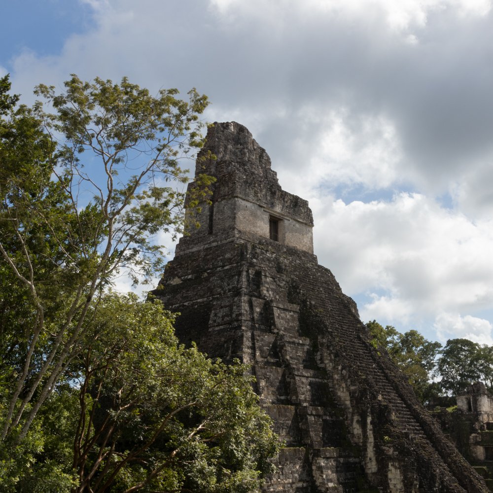
14. Caana
Caana (meaning “Sky Palace”) is the most prominent structure in Caracol, and is still Belize’s tallest man-made structure at 141 feet (43 meters).
Caana was built over a long period, but was likely not finished until at least AD 760. The large structure combines at least 60 rooms, four palaces, and three temples.
15. Caana View #1
From atop Caana, one can see across the jungle and into Guatemala.
16. Caana View #2
Looking back towards Structures B4, B5, and B6, one gets a sense of how Caana dominates over Caracol.
17. Caana View #3
Structure B18 is one of the buildings combined to make Caana.
18. Structure A2
Structure A2 is one of the oldest in Caracol, and contained a tomb and many stelae. Major excavation on Structure A2 began in 1990.
In the early years of Caracol, the A Group of structures possibly served as an astronomical observatory, allowing residents to accurately track and mark the movement of the sun.
19. Excavation Complication
Trees and structures now form a complementary relationship, with each integral in physically supporting the other. This complicates excavation, as damage to the trees could potentially prove catastrophic to the structure.
It is easy to travel to sites like Tikal and Caracol and marvel at what has been unearthed without really giving extensive consideration to the painstaking efforts of archaeologists in carefully uncovering and preserving these sites for future generations. While many groups can claim to contribute to Caracol’s excavation, the University of Nevada - Las Vegas has sponsored archaeological digs and research at Caracol since the 1980’s, and is arguably the most responsible for the bounty of recent historical finds here. While advanced technology -such as LiDAR- has aided archaeology in the last couple of decades, the vast majority of digging, cataloguing, and preserving is done by hand. My hat goes off to those doing this arduous work so that those like me can appreciate it.
20. Caracol A-Ballcourt
The Mayan Ball Game was a central part of the civilization, and probably held deep religious and ritual meaning.
There exists no authoritative understanding of the Mayan Ball Game, played on courts such as this for millennia before the arrival of European colonists. What is known is the game was played between two teams, and used a large rubber-like ball. The objective of the game is thought to be to pass the ball into a hoop using any part of the body but the hand and foot. Given the presence of large ball courts throughout Central America, the significance of such events cannot likely be understated. This ball game is perhaps the world’s oldest form of sport.
21. Caracol A-Reservoir
It is thought that water reservoirs were not only supreme examples of engineering for the time, but were used by Maya elites to control the local population.
Caracol has no rivers and is believed to have no natural pools of water. As such, reservoirs such as this had to be dug and lined in order to catch rainwater.
22. Rio On Pools
Rio on Pools is a popular swimming destination on the road to Caracol.
Our time in Caracol came to an end as we had to link up with the reverse convoy heading back to Douglas da Silva. On the way back to San Ignacio, we made a quick stop at Rio on Pools for some swimming. Not having brought any swim trunks, I opted instead to take a photograph of the waterfalls here. We also made a very quick stop at the nearby Rio Frio Cave, although I admittedly didn’t think to take a photograph.
Returning to Windy Hill Resort, I had a meal in their restaurant and a few drinks at their bar before turning in for some sleep in anticipation of the following day’s long trek to Actun Tunichil Muknal.
23. Actun Tunichil Muknal
Actun Tunichil Muknal is a Maya archaeological site located in the upper chamber of a cave in the Tapir Mountain Nature Reserve. The cave is accessed by a jungle walk, which itself includes three crossings of the Roaring River.
Visiting Actun Tunichil Muknal (Cave of the Crystal Sepulcher, or -colloquially- ATM) is one of the greatest adventures I’ve ever been on. First things first, to reach the cave itself you must take a trek into the jungle. While the path is well-worn, you feel completely and totally separated from civilization, and you can’t help but have a feeling in the back of your mind that a jaguar or a crocodile will be around the next corner. To add to the Indiana Jones-style adventure, you must cross the Roaring River three times. I am not a strong swimmer, but I had no problem pulling myself across with the provided ropes. Your results may vary depending on what time of year you visit, but the river itself was relatively calm.
Once you reach the opening of the cave, you must swim, climb, and crawl what I estimate to be 2/3 of a mile (one kilometer) to reach the passage to the upper chamber. Here, Maya pottery and human remains are found. The most famous of the remains here is the so-called “Crystal Maiden”, an adolescent who was likely sacrificed in situ.
Some things to keep in mind: first, some years back, a tourist dropped a camera on a skull inside the upper chamber, and -as such- photography of any kind is now prohibited. You may be shocked to read this as I am obviously a photographer, but this is probably for the best - the inevitable flashbulbs would, in my opinion, really ruin the sense of adventure. The first river crossing pictured above is about as far as you can venture with a camera before needing to lock it up in the tour van.
A second thing to remember is that, while ATM is not a terribly strenuous tour, there are some difficult parts to navigate. First, to reach the upper chamber, you must climb a sizable rock ledge (I’d estimate it at about 10 feet / 3 meters). The rock itself is slippery and the cave is fairly dark, but the tour guides seemingly do a great job of assisting folks. Second, on the way out (you take a different route in and out, presumably as crowd control), there is a rather narrow passage (I’d estimate 14-inches / 35 centimeters) that you must navigate for about 10 feet / 3 meters. Being a bit broad-chested myself (U.S. 44 / European 54 suit size), there was little chance of me slipping through there. Thankfully, if you are in the same situation, you can swim the 10 feet / 3 meters underwater. Needless to say, this cave is not for the hyper-claustrophobic, but it is certainly much more manageable than other formations I have been in, namely the slot canyons of the American Southwest.
After one last night at Windy Hill, it was time to leave Belize. Overall, I had a great, albeit short, trip. While I am certain there is much more to do in Belize (particularly leisure activities such as canoeing and beach-going), I felt I checked enough boxes to make it extremely worthwhile. And while I just scratched the surface in Guatemala, I am glad I reached Tikal now instead of trying to add it to a trip focusing on the southern part of the country.