Custer State Park & Badlands National Park
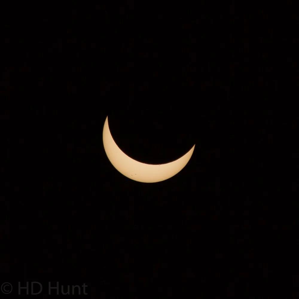
Day Three - The Great American Eclipse - 2017
A morning spent exploring Custer State Park, followed by an afternoon at Badlands National Park and Minuteman Missile National Historic Site.
Base Map Credit: OpenStreetMap
1. Custer State Park #1
Encouraged by what we saw in the southern unit of Custer State Park the day before, we decided to wake up early and explore the northwest corner of the park in the morning before heading to Badlands National Park. Admittedly, I don’t have a whole of context to add to this photograph and the eight that follow it other than this is a fantastic two-hour long drive, and I encourage any visitor to the Black Hills to take the time out and check this route out.
2. Custer State Park #2
3. Custer State Park #3
4. Custer State Park #4
5. Custer State Park #5
6. Custer State Park #6
7. Custer State Park #7
8. Custer State Park #8
9. Custer State Park #9
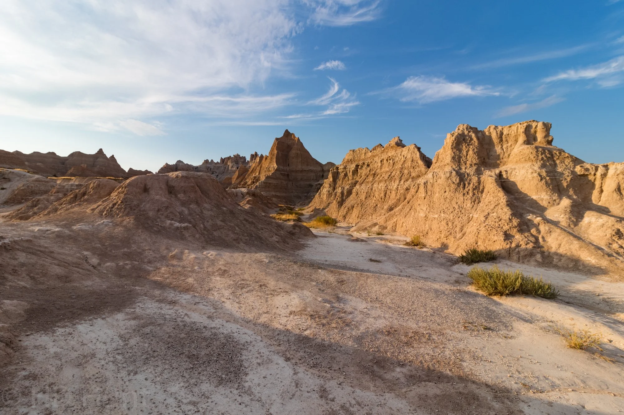
10. Badlands National Park #1
The .5 mile (.8 kilometer) Cliff Shelf Trail gives hikers a view over the White River Valley.
We had an appointment for the Delta-01 Tour at Minuteman Missile National Historic Site, but with some extra time to spare, we decided to check out the easternmost part of Badlands National Park, the Cedar Pass Area, first. This area has many short hiking paths easily accessible from the park’s main road. The first pull-off from the Interior Entrance is the Cliff Shelf Trail. The following photograph is also from the Cliff Shelf Trail.
11. Badlands National Park #2
12. Badlands National Park #3
Window Trail is a short boardwalk leading to a view of a heavily eroded canyon.
A short distance from the Cliff Shelf Trail is the Window Trail. A short, level walk rewards you with a fantastic view. The following two photos are also from Window Trail.
13. Badlands National Park #4
14. Badlands National Park #5
15. Badlands National Park #6
Door Trail leads you to an overlook across eroded sedimentary rocks which truly define the term, “badlands.”
The northernmost trail in the Cedar Pass Area, Door Trail, has some of Badlands National Park’s best vistas, which typify the views visitors likely associate with the park. The following two photographs are also from Door Trail.
16. Badlands National Park #7
17. Badlands National Park #8
We run this website for free - show your support with a follow on Instagram!
Thanks for your support!
18. Minuteman Missile National Historic Site #1
The Delta-01 Launch Control Facility is divided into two halves: an upper, or “Topside”, half, and an underground portion 31 feet (9.5 meters) underground.
After (temporarily) leaving Badlands National Park, we visited the small but informative Minuteman Missile National Historic Site Visitor’s Center, which is located not far from Badlands’ Northeast Entrance. Afterwards, we made our way to the second part of the Historic Site, the Delta-01 Launch Control Facility. Due to the close quarters of the facility and the need for a guided tour, access to this part of the park is limited and by appointment only. While the Visitor’s Center is a building built specifically for exhibitions, Delta-01 is where nuclear missileers actually worked during the height of the Cold War. Basically, should a nuclear strike have been ordered, the missileers on duty had the responsibility of confirming the order and executing the launch. The missile itself would come from a nearby silo, one of which currently forms the third part of Minuteman Missile National Historic Site. Delta-01 is one of a hundred such facilities which were scattered across the Great Plains at one point in time as U.S. Department of Defense policy mandated one such facility for every ten missiles.
The facility itself is divided into two halves. The upper, or “Topside” half, housed security and logistics staff for the launch facility. In the underground half, the missileers would work on 24-hour shifts manning the weapons system itself. Two personnel would always be present underground, as it would take two people to use the launch system.
19. Minuteman Missile National Historic Site #2
Security was paramount, as punctuated by the eight-ton blast door which sealed the launch crew in.
20. Minuteman Missile National Historic Site #3
Ordering a nuclear launch was (and still is) a complex series of procedures and cross-checks executed expeditiously by multiple military authorities. Once the President determines the need to execute a tactical strike, he consults with the Joint Chiefs of Staff to determine options. Once an option is selected, the President activates the “Nuclear Football”, and passes a launch authorization code to the Pentagon. The Pentagon then passes that code along to the executing launch site.
21. Minuteman Missile National Historic Site #4
The code, which takes the form of an "Emergency Action Message", is received and verified by the two missileers on duty in the bunker by cross-checking the code with an unopened, rotating code kept on-site. Once the launch code is verified visually, it is entered into the launch system for further authentication.
22. Minuteman Missile National Historic Site #5
At this point, the code is authenticated and the tests of the Minuteman II missile platform begin. The launch coordinates are transmitted to the missile during this phase.
23. Minuteman Missile National Historic Site #6
The missile is cross-checked for launch worthiness, and its ability to execute the strike is verified.
24. Minuteman Missile National Historic Site #7
At this point, the two missileers must agree to execute the launch simultaneously. Two consoles placed 12 feet apart contain two key controllers which must be turned within two seconds of one another. This "two man" system ensures, of course, that one person cannot physically execute a launch sequence. Once the keys are turned and the launch levers toggled, the Minuteman Missile would launch from its blockhouse several miles away (the distance deliberate so as to necessitate two separate strikes to destroy both the blockhouse and the control room).
25. Minuteman Missile National Historic Site #8
After the hour-long tour, we returned to the surface with a new appreciation of how the end of the world was -and, perhaps, still is- one phone call away. Afterwards, we visited the Delta-09 Minuteman II Missile Silo, and then stopped at Wall Drug Store before heading back into Badlands National Park.
26. Badlands National Park #9
The Hay Butte Overlook looks down towards Sage Creek.
After re-entering the Badlands, we opted to head first to the Hay Butte Overlook, located on a dirt road just off the Badlands Loop Road.
27. Badlands National Park #10
The yellow rock from which Yellow Mounds Overlook gets its name is the result of the erosion of mud that was deposited during the recession of a one-time inland sea.
Moving back onto the Badlands Loop Road, we stopped at Yellow Mounds Overlook, which likely provides the most complete geologic record in Badlands National Park. The colorful, diverse layers here are the result of 75 million years of deposit and erosion. The following two photographs are also from Yellow Mounds Overlook.
28. Badlands National Park #11
29. Badlands National Park #12
30. Badlands National Park #13
Burns Basin Overlook is named for Wilson Burns, who homesteaded sheep here at the beginning of the 20th century.
Moving further down Badlands Loop Road, we visited Burns Basin Overlook…
31. Badlands National Park #14
Panorama Point offers wide-open views south to where the badlands meet the prairie.
…And then Panorama Point…
32. Badlands National Park #15
White River Valley Overlook visually suggests to visitors the erosion that has occurred to these cliffs since they were initially carved by White River, which now lies five miles (eight kilometers) away.
…And finally White River Valley Overlook before heading out to the town of Interior to get fuel.
33. Badlands National Park #16
Two bighorn ram graze in a field.
On the way back from Interior, we came across some bighorn sheep.
34. Badlands National Park #17
35. Badlands National Park #18
Pinnacles Overlook lies at the highest point of the Badlands Loop Road, affording commanding views across the surrounding territory.
We ended our day -and our trip- at Pinnacles Overlook, which is renowned for its tremendous views and even more tremendous sunsets. All in all, this was an amazing albeit jam-packed three days, and -if I weren’t absolutely certain I would come back here one day in the future- I’d be somewhat sad I didn’t take three more days to explore since there is so much more to see and do in the Black Hills, including Wind Cave, Jewel Cave, and countless hiking paths and scenic bypasses. Moreover, these quick stops were the perfect way to book-end The Great American Eclipse, and I am glad I chose this part of the United States to visit in tandem with that event.