Amman, Jerash, Madaba, & Shobak
Days Two & Three - Jordan - 2023
A full day exploring Amman’s Citadel and the archaeological site at Jerash, followed by a southward journey with stops at Madaba and Shobak, among other locales.
1. Temple of Hercules #1
The Temple of Hercules is the centerpiece of the Amman Citadel.
The Citadel -and by extension, Amman itself- is one of the most fascinating places on earth from a cultural perspective. Evidence has suggested that the area that is presently Amman Citadel has been occupied -or, at least used in a communal way- since 7,000 BC. Civilizations such as the Assyrians, the Babylonians, the Seleucids, the Romans, the Byzantines, and the Umayyads left their mark on this hilltop.
This intersection of cultures results today in an incredibly high density of archaeological and cultural sites from across the ages. The major features that can be visited today include the remains of the Temple of Hercules, the Umayyad Palace, and the remains of a Byzantine Church, but only a fraction of the site has been excavated and there certainly are other wonders awaiting excavation beneath your feet!
2. Temple of Hercules #2
It is believed that the Temple of Hercules was never completed, but would have been larger than any temple in Rome.
Construction on the Temple of Hercules began in the 2nd century, but likely ceased upon the fall of the Western Roman Empire and the corresponding rise of the Byzantine Empire.
3. The Hand of Hercules
A large statue of Hercules once stood in the Amman Citadel, but was likely felled by an earthquake; only part of a hand and an elbow remain today.
Earthquakes were a common terror around the Jordan Valley, particularly in the first millennium when at least three major earthquakes struck: 346 AD, 749 AD and 1033 AD. It is likely the 749 earthquake felled the Hercules statue along with several buildings and columns in the Citadel.
4. The Raghadan Flagpole
The Raghadan Flagpole was once the tallest free-standing flagpole in the world and can be seen 20 kilometers / 12 miles away on a clear day.
The Raghadan Flagpole is located on the grounds of Al-Maquar, Jordan’s royal residential complex, which is a good enough excuse for me to talk about the Hashemite dynasty and how they came to power in Jordan. Direct descendants of Muhammed, Sharif Hussein was appointed Emir of Hejaz (the area around Mecca) by the Ottoman Empire. Initiating a compact with the British to ensure Arab independence after World War I, Hussein was able to position his three sons to rule Hejaz, Iraq, and Jordan, the latter of which passed to Abdullah I who served as Emir of Transjordan until Jordanian independence from Britain in 1946. Controversially annexing the West Bank in 1949, Abdullah was assassinated in Jerusalem in 1951; he was succeeded by his grandson, Hussein, the following year. Hussein -who ruled until 1999- oversaw the transformation of Jordan into a modern state equipped to balance the demands between powerbrokers such as the United States and the Soviet Union, particularly as related to Middle Eastern affairs. He was succeeded by the present monarch, Abdullah II, and was buried in -you guessed it- Al-Maquar.
5. Jordan Archaeological Museum #1
The lid of an anthropoid ceramic coffin, which were vessels for offerings popular between the 14th and 10th centuries BC and valuable archaeological finds today.
I took a few minutes to wander around the Jordan Archaeological Museum, a small collection on the grounds of the Citadel which houses all sorts of finds from sites across Jordan. You can make the loop in less than 10 minutes, and is worth a quick spin if you’re visiting the Citadel. Another photograph from the museum follows.
6. Jordan Archaeological Museum #2
The Jordan Archaeological Museum houses some of the world’s oldest statuary.
7. The City Surrounds
Amman’s population has exploded over the past 150 years (from 500 persons in 1879 to over 4 million today); as such, modern Amman have swallowed up historic districts such as the Citadel.
As mentioned, the Umayyad Palace and the remains of the Byzantine Church are also on the site and are worth a few minutes of your time before you head back to the gate.
8. View From Amman Citadel
(Click here to view a full-size version of this panorama.)
Amman initially occupied seven located around the current downtown core before its outward expansion; it now covers nineteen such hills.
One of the best features of the Citadel is its commanding views of the city, a panorama of which I captured above.
After concluding our morning visit to the Citadel, we made our way north to Jerash.
9. Arch of Hadrian
The Arch of Hadrian is the southern gate of Jerash, built in honor of a visit by the Roman Emperor of the same name to the city in the 2nd century.
Arriving in Jerash -often referred to by its Greek name Gerasa- is a bit like going to a large international airport as you must pass through all matter of shops to get to the gate. The gate, in this case, is the Arch of Hadrian, the southern entrance into Jerash. Once you walk through the gate, you might ask yourself what this location did to deserve the title of “Pompeii of the Middle East”, since -well- there isn’t much to see. Good news is that everything you seek here is, literally, just around the corner.
Jerash is worthy of praise due to the incredible size of the size, the extent of the excavations carried out there, and its overall outstanding preservation. I do think the title of Pompeii of the Middle East is a bit misguided and perhaps hyperbolic, but there is certainly no shortage of sites here.
10. The Hippodrome
Jerash’s massive Hippodrome could seat 15,000 for chariot races; it also hosted a segment of Top Gear’s Middle East Special.
The founding of Jerash is contended by historians. Based on inscriptions discovered on the site, some attribute the founding of the city to Alexander the Great. Others contend the Seleucid king Antioch IV founded the city, while others still Ptolemy II of Egypt. Regardless, after brief Judean stewardship, the Romans conquered the city in around 63 BC. and within a hundred years or so they did what Romans do and built a hippodrome ...
11. The Oval Forum
The Oval Plaza is ringed by over 60 columns, in between which stalls would be set up with traders selling goods.
… and they built a forum, a type of public square at the time. But this forum is unique in that it is oval(ish) instead of rectangular. The reasons why is a bit convoluted, but basically the main road (which we will talk about in a minute) followed a natural contour in the earth; this contour intersected an existing structure (a sanctuary to Zeus) at an odd angle, and so an oval was used to make this intersection more flattering than it would be than if it were an oddly bisected rectangle.
If it is helpful to understand my nonsense more completely, here’s an overhead image:
12. The City of a Thousand Columns
At the peak of its magnificence, Jerash had over one thousand columns, giving it with a nickname which persists to this day.
During the Roman period, Jerash lay on a major trade route the Empire established throughout the Middle East. This led to tremendous wealth in the city, which expanded quickly while becoming more opulent. During this period, many temples were constructed and its main road was lined with hundreds of columns. After the Western Roman Empire fell, Jerash retained importance in the Byzantine Era which followed. It was during the period of the Umayyad Caliphate that a devastating earthquake struck in 749, reducing much of Jerash to ruin and resulting in the abandonment of the site to time. In contemporary times, the ruins of these fallen columns were often easily reconstructed, giving visitors a hint of Jerash’s full opulence.
13. The Macellum
A macellum was an ancient Roman indoor market, commonly selling meat and fish.
A little bit of imagination is required when visiting Jerash, but certainly quite a bit less than at other sites whose remains border on the abstract. While not as complete as the macellum in Pompeii, for example, it is easy to understand where the vendors’ stalls would be located, and there are even stones you can easily imagine as butchering blocks. It is for this reason that the nickname Pompeii of the Middle East is applied.
14. The Nymphaeum
The Nymphaeum not only served as a temple for the nymphs, but was a fountain at which drinking water could be collected.
Of the various features I saw at Jerash, the nymphaeum was by far the most impressive. It is easy to imagine that it would still work today, but my understanding is that the underground spring which fed it has moved over time. Considering this was built in 191 AD, it gives you a good understanding of the wealth this city once had.
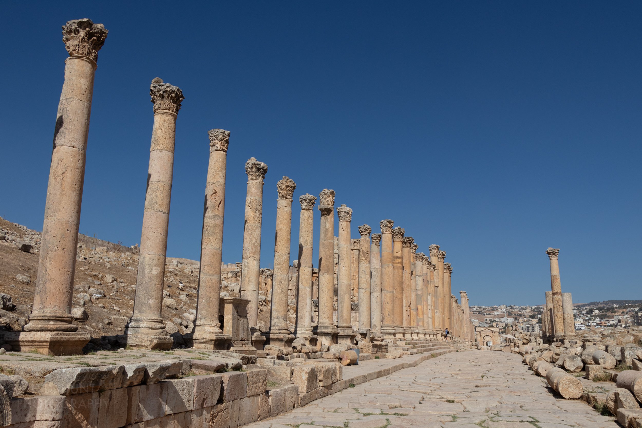
15. The Cardo Maximus
The Cardo Maximus -also known as the Colonnaded Street- is over 800 meters / 2600 feet long.
There’s no other way to put it: the Cardo Maximus in Jerash is just cool. Once lined with over 500 tremendous and ornate columns, the original path stones show original wear from chariot wheels. The street -which I mentioned earlier was intentionally built over a natural ditch feature- had gutters and manhole covers which could carry rain and waste water away from the city. Walking here, it is very easy to be transported to a time gone by.
16. The South Theater
The 3,000 seat South Theater is still used today due to its exceptional acoustics - even a mere whisper at the center of the theater can be heard in the upper rows.
On the way back to the Arch of Hadrian, we stopped at the South Theater as our last stop of the afternoon. There’s so much to see in Jerash, and I feel like I maybe saw 60% of the site in the four hours I was there. Other sites not covered here include the Temple of Artemis, the Three Churches, and the Baths.
After departing, we made our way back to Amman for one last night in the city.
Hey, you! Enjoying this content?
Consider giving us a follow!
Thanks for your support!
17. A View of the Promised Land
(Click here to view a full-size version of this panorama.)
In the Old Testament of the Bible, Moses climbed Mount Nebo to see the Promised Land just prior to his death there.
Early in the morning, we made our way to Mount Nebo where, according to religious texts, Moses viewed the Land of Canaan and where he died. As Moses is a central figure in many faiths -including the Abrahamic faiths- this location has become one of the world’s most significant pilgrimage destinations. The view looks across the Jordan Valley towards the city of Jericho and the Mount of Olives.
As you can see, the view on the day of my visit was typically hazy; however, I could still make out the Dead Sea, Qumran, Jericho, and the Bethany Beyond the Jordan baptismal site. You also get a sweeping view of the Jordan Valley some 1,100 meters / 3,600 feet below.
18. Mount Nebo Mosaic
The Diakonikon Baptistery Mosaic was not rediscovered until 1976 after centuries of being hidden beneath another, more simple, mosaic floor.
As mentioned, Mount Nebo is a place of veneration as it is the location of Moses’ death. A pilgrimage church was built on Mount Nebo in the 4th century, but was lost to time until it was “rediscovered” in the 1930s. During subsequent excavation, elaborate mosaic floors were discovered. A re-consecrated church now sits on the site of the former, and visitors to Mount Nebo can see these mosaics themselves, which are incredibly vivid due to being hidden for so long.
19. The Madaba Map #1
The Madaba Map is perhaps the world’s oldest map in art history.
We next made our way the nearby city of Madaba lies perhaps the most significant of the Byzantine-era mosaics – the Madaba Map. This tile floor within Saint George’s Church is the oldest surviving cartographic depiction of the Holy Land. The map likely dates to around 500 AD. As a former cartography student with an obvious interest in historical matters, this is a site I had very much longed to see!
Editorial Comment: A roll-over version of this map can be found on Wikimedia here along with an exceptionally high resolution, detailed recreation which can be found here.
20. The Madaba Map #2
The Madaba Map establishes the location of the site of the baptism of Jesus Christ.
In the area just north of the Dead Sea, the map translates to, “Bethabara, the place of St. John's baptizing." Note the fish depicted in the Jordan River, a symbol of Jesus Christ. This area is also the only segment of the map which features animals.
21. The Madaba Map #3
The map’s depiction of Jerusalem is so detailed it allowed for an extremely accurate dating of the map based on the presence and absence of specific buildings within the city.
Upon conclusion of our review of the Madaba Map, we turned south and headed towards our destination for the evening, Wadi Musa. We were given a choice of visiting Kerak Castle or Shobak Castle en route. Not having a strong opinion one way or another, the group chose Shobak since it was more easily accessible and many wished to arrive early into Wadi Musa to attend Petra by Night.
22. Shobak Castle #1
Shobak is one of two Crusader castles along the King’s Highway, along with Kerak Castle.
Shobak is certainly less well known and, therefore, less visited than Kerak; it is also more “authentic” because it has not undergone the extensive renovations that Kerak has.
Shobak -also known as Montreal- was built in the early 12th century by Baldwin I of Jerusalem. Baldwin -son of a nobleman who fought on the victorious side at the Battle of Hastings and brother of Godfrey, a commander of the First Crusade and first “ruler” of Jerusalem- ascended the throne as “King” of Jerusalem upon his brother’s death and his brief conquest of the title. Baldwin wished to control the trade route between Egypt and Syria, as well as tax pilgrims headed to Mecca and Medina. Selecting a site atop a hill above a verdant valley along this route (now the King’s Highway), he had Shobak built in 1115.
In 1142, the seat of the Kingdom of Jerusalem moved to the newer and stronger Kerak Castle, and Shobak was given to the so-called Lordship of Oultrejourdain, who called it Montreal. Fast forward, and Ayyubid sultan Saladin (yes, that one) invaded in the region in 1187. After capturing Jerusalem, he lay siege to Montreal, which resisted for two years before falling. The Ayyubids modified the castle extensively, and it eventually fell into Mamluk hands before falling into disuse. As a result, Shobak has Crusader, Ayyubid, and Mamluk influence.
Six more views of, and from, Shobak Castle follow.
23. Shobak Castle #2
24. Shobak Castle #3
25. Shobak Castle #4
26. Shobak Castle #5
27. Shobak Castle #6
28. Shobak Castle #7
29. Sunset Over Wadi Musa
Wadi Musa means, “Valley of Moses”; the ancient figure is claimed to have struck a rock here which turned into a spring, water from which was ultimately redirected by the Nabateans towards Petra.
Wadi Musa is notable for two reasons: first, its association with a story from the Bible concerning Moses creating a spring from a rock, and, second, its proximity to Petra. While the former may have resulted in a few pilgrims stopping by over the centuries, it is from visitors to Petra to which Wadi Musa owes its prosperity. Besides the tiny roadside attraction that is Moses’ Spring, the whole of Wadi Musa exists to support the tourism industry here, with never ending hotels, restaurants, and shops.
Unfortunately, the local Bedouins who once inhabited Petra have been mostly left out of this equation over the years. Pardon the dovetail, but I want to take a moment to mention the Bedul people. In 1985, UNESCO stated that -in order to comply with the requirements of World Heritage Site recognition which forbade human occupation at such sites- the Bedul Bedouin people who lived in the caves of Petra had to be relocated. The Bedul first suggested a site south of the Archaeological Park, but this was rejected, presumably because access to goods from Wadi Rum would have to pass through Petra’s core. A site was provided, now called Umm Seyhoun, to the northwest of Wadi Musa.
I won’t editorialize the decision-making here because I’m not sure there would have been any agreeable solution to this issue; however, I will say that this movement of the Bedul people had two effects: first, it made an historically Bedouin people sedentary, and, second, it caused the Bedul to miss out on the immense profits in Wadi Musa from the tenfold per annum increase in the number of visitors to Petra since their forced movement.
I am not certain what the future will hold for the Bedul (nor should I be), but I’d like to think that an accommodation can be made to avoid the extermination of the Bedouin lifestyle these people had for centuries.


